September 13, 2022
Today was filled will all types of great and not so great things making it a real adventure.
The morning wasn’t as chilly as yesterday so it was easier to roll out of the sleeping bag and get the day started. I waited until it just started getting light and had a nice view of Roosevelt Lake and the hills across the other side. Packing up was the usual routine that I have down pretty well. Oatmeal was on the breakfast menu. Just like my dinners, boiling water is all that’s required.

I headed into the town of Grand Coulee and gassed up before heading over to the dam’s visitor center. It’s located next to the dam itself and provides a great view. There is a tiered seating area which, I think, must be for the evening light shows. I parked and took a few pictures before entering the center.


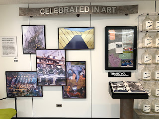
The visitor center is done very well with lots of displays, some interactive, explaining the purpose of the dam: produce electricity, water for irrigation, and flood control. Other exhibits covered hydrology, the building of the dam, it’s impacts on the Native people living in the area, and even some art produced in the 1960s about the dam.


I went upstairs and watched about 25 minutes of a 45 minute film about the building of the dam and it was excellent. Lots of vintage film from the early 30s when it was begun. I didn’t stay for the whole film because I still had a long ride ahead of me and needed to get going.


When I returned to the parking lot, 2 other bikes, BMWs, had parked next to me. I never saw the riders but they were riding 2-up since each bike has 2 helmets on it. One bike was from Washington and the other from Montana.

I made a change to my packing and moved my iPad from the side case to my satchel so I could run a power cord to it and have it charge while I rode. I ran an extension USB cord from my tank bag’s charging connection, along the seat, and into the bag. Keeping things charged when not having regular access to electricity is something to keep on top of these days with our portable devices.

The route took me across the river and directed me north. This was across a large reservation and a varying landscape of a deep canyon cut by the Columbia River and rolling hills on the other side. I went through lots of small towns along the way. I stopped in Winthrop for a photo as this place was obviously touristy. It was looking like an old logging town but seemed as authentic as the Old West main street at Knotts Berry Farm. I was glad my route had me avoid most of it.

After a while, the mountains became closer and the road started uphill. I wasn’t sure if the clouds over the mountaintops were fog, smoke, or were thunderheads but as a few raindrops started hitting my helmet I figured it was time to pull over and get my rain gear on. This involved getting the liner for my jacket out and getting it snapped and zipped in. Then I got out my rain pants that fit over my regular riding pants. I had to take my boots off to get them on and right about that time, 3 other motorcycles pulled in to do the same thing I was.


About the time we were all rainproofed, the rain stopped, but we could hear lots of thunder coming from the direction we were heading. The other three riders were from Washington and headed out to join another group for a longer ride. These guys were a mixed bag of bikes: a Harley, a BMW, and a another bike of brand unknown to me.

They took off and I was a few minutes behind them. It didn’t take long before the sky really opened up. I have some experience riding in the rain after the deluge I rode through in Minnesota last summer but it took me a bit before trusting both my skill set and the bike to relax and just ride. About 15 minutes into the rain it switched to hail for about a minute or two or three. The hailstones were small, maybe 1/4”, and I wanted to pull over but there was nowhere to do that so I forged ahead. After a bit the rain, the weather lightened up and I had a great opportunity for a photo.


This is a beautiful ride, even with the rain coming and going. At least I am staying totally dry and warm. The grip heaters are nice for the warm part. I stopped for a few more photos before the road took me out of the mountains and opened into farmland and the occasional small town.


I stopped for gas in Marblemont.


I hit some road construction and, while it wasn’t that bad, I did have to navigate a bump or two. The next thing I know is that my check engine light came on. Uh-oh. This only happened once before and that was last year when I was coming across North Dakota and entering back into Montana. I’d hit a bunch of grasshoppers and the cruise control disconnected and the check engine light came on. After returning home I bought an adapter cable for my OBD2 reader and saw that it was a “520” error, something about a lost signal from the IMU, some kind of Inertia Motion thing that amounted to nothing.
So, what is up with it this time? I pulled over in a picnic area, unloaded the gear off the bike, and removed the seats to get to my reader which I keep stored under there and to the connection I need to plug into. I fired things up and it it gave me a 520 error.


I thought it might be the same as last year but pulled my service manual up on my phone to make sure. (I’d scanned the whole manual and keep a copy both in the cloud and on the phone for situations like this.) Sure enough, the same as last year so I cleared the code, reloaded the bike, and got on my way.


I was using Google navigator to direct me so I wasn’t looking at a map but it took me on a terrific 20-mile ride on a road that ended in Deming, WA. It was one of the best rides I’ve ever done. It was through dairy farmland and the 2-lane road was twisty with lots of rolling ups and downs. I stopped for a photo and those 3 bikes I met when we were donning rain gear rode by. (I later looked at the photos I shot on that road and the GPS showed me that it was Hwy 9 from Sedro-Woolley to Deming, the Valley Highway. Highly recommended.)


At some point, Google navigator messed up as I came out a roundabout and sent me down a dead end road. I turned around and guessed which way I should go and eventually got back on track. Another 45 minutes later I arrived at the Birch Bay State Park. I was unable to get a reservation in advance when I tried to do it last night because I was too close to my arrival date and now the person at the gate was gone for the day. I read the instructions and I had to look at a list of available sites and then cruise the park to check them out, pick one, and then come back and register the old fashioned way: fill out an envelope, put in the fee, drop it in a box.


I am not fussy about my site as long as there is a table, a spot for my tent, and place to park the bike where I can drive out and not have to push it back up a hill. The site I picked was fine and, while the park is really full of RVs, I was more or less alone. Before I went back to the site, I rode back out 1/2 mile to a little store to pick up some beer to go with my dinner.
I got the tent set up and the water boiling. I had lasagne with a nice IPA.


No comments:
Post a Comment