Wednesday, October 18, 2023

A 24-hour Overnight Trip

October 16, 2023

I did a nice 7-mile run first thing in the morning and after getting cleaned up having breakfast I glanced at the weather report and it really did look like beautiful weather for today and at least into early tomorrow afternoon.  It’s the middle of October and with fall clearly underway, the number of good riding days are dwindling away.  I decided to grab a quick overnighted so went out and loaded up the bike and headed for the Bighorn Mountains.

I had nothing complicated planned but just wanted to ride for a couple hours, park at a campsite, do a little hike, sleep in a tent, and ride back the next day.  The Five Springs campground east of Lovell, WY is an easy one to do.  I stayed here last Fathers Day but am taking a more direct route this time.  I road south from Laurel on Hwy 212 until I switched to Hwy 310 in Rockvale, traveling then through Fromberg and Bridger.  My first stop was after crossing the Wyoming border in the village of Frannie.


Frannie is a Port of Entry for Wyoming and has a nice little park next to their water tower.

I pulled into Crowley, WY and took a slight detour through the town to see their “historical district.”  I passed what looked like an old school and that was it.  I stopped at the next intersection and took thos boring photo.


When I arrived in Lovell, WY I pulled over for these two photos.  That’s a very cool looking theater and I like the bee-like paint job on the honey business.


This next photo is just looking out the east end of Lovell.


A few miles outside of town I switch to Hwy Alternate 14, AKA 14A.  I’ve ridden this road in the past and  about 20 miles out of town is become very steep and twisty.  I’ll be turning off just before that.  Here are a couple photos where I turned off toward the campground, which is on old 14A.


This sign explains the history of the road.


On the way up the 2-mile ride to the campground, on a very narrow, twisty but paved road, I stopped for this photo.


While I was pulled over a pickup came by, heading downhill, and stopped to humorously ask me how I was going to haul a deer on my bike.  I guess hunting season is on.

I arrived at the campground and negotiated the rough and rutted road to the upper campsites. 


I was surprised to find 3 pickups and a utility trailer parked there.  I parked and wandered onto the bridge that crosses the stream and saw that the group camping site had several very large tents and lots of camping equipment.  Ah, it’s a hunting party.  I’d noticed that the trucks all had California plates so it must be a guided excursion of some kind.

I grabbed site #8, which is the one I’d planned to get, and then walked back down the hill to register.  Camping is $7 but half price with my Interagency Pass.


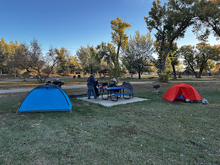
I got the bike unpacked and set up my tent. 


 I changed out of my riding gear and headed out for hike up to the water falls.


This is the lower falls.  The upper falls are viewable but hard to get to.  Here’s short video of them.


I’m no rock climber and when I saw the route to the upper falls I decided against it.  A fall when out alone could have deadly results.

As it started getting dark I got my dinner ready.


It started looking like time to head for the tent.


I didn’t check the temperature but I think it was down to the upper-30s overnight.  I had my heavier sleeping bag so I stayed plenty warm and serenade by the fast moving stream about 25-feet away from my tent.

Once it started getting light I got up and fired up the stove to make a cup of herbal tea.  I noticed that the hunters were gone except for one truck left behind.  I was surprised that they made almost no noise last night and had left this morning without waking me.

I had my breakfast and broke camp and loaded up the bike.  


When I headed out, the air temperature was about 50 degrees.  I headed back down that narrow road and pulled over a few times for photos.


Aside from the occasional pothole, one has to watch for rocks on the road.


I got down to Hwt 14A and headed back the way I came.  I crossed the Bighorn Lake/River and had to stop for construction.


While waiting I also took this photo looking back.


I’d thought about turning north on Hwy 37 to checkout Horseshoe Bend along the river but all the truck hauling stuff for the road construction project were turning there and I wasn’t in a good position to do the same so I put that off for next time.

The rest of the ride back was pleasant.  It stayed cool but by the time I got to the rest area outside of Bridger it had warmed up so I stopped to shed a layer and change to my lighter gloves.  While I ate an apple a couple from Worden stopped and told me about their quick trip into Utah.

I arrived home after covering 237 miles in the two days, 23-1/2 hours after I’d left.


I unloaded the bike, put it away and got ready to meet a friend for a run that turned out to be 7-1/2 miles long.  Here’s some photos from that:


Wednesday, October 11, 2023

An International Ride - Day 2

October 10, 2023

We camped in Trafton Park in Malta which is the city park along the Milk River and, as a city park, one is serenaded by a cacophony of city sounds: cars driving through the park, traffic on nearby Hwys 2 and 191, dogs barking, and a train going by every couple of hours.  I pretty much slept OK, even with the clatter and the cool temperatures.  We both got up about the same time and got moving around to stay warm.


The park is actually quite nice and the price is good too: $5.  We were not alone as there were a couple of RVers there as well.

We went through the ritual of getting packed up, a process that, from experience, takes the best part of an hour.  The itinerary I’d made had us leaving at 9am and it was 8:54 when we started up the bikes.  We’d both gassed up yesterday so we were ready to roll.  The first stop was there in Malta at the Phillips County Courthouse to add to my collection of photos of my bike parked in from of courthouses.  This one is pretty nice.


Then it was back on the highway and instead of 191 we were headed west on Hwy 2, formally known as U.S Route 2, which extends from Maine to Washington state and has its own Wikipedia page. In Chinook, MT we pulled over at a historic point that explained the Battle of Bears Paws, a sad part of our history.


The next stop was in Havre, MT for gas and another courthouse photo.  We are in Hill County now.


BTW, my bike continues to average a bit over 54 miles to the gallon on 87 octane regular.

Havre is a pretty good-sized city and maybe a place to come back and visit someday.  We hunted down Hwy 87 and headed south.  It’s still a bit brisk out but I am staying comfortable with my grip headers on the medium setting.  Here’s a couple photos of the landscape just north of Fort Benton.


The terrain in this part of the state is easy to view as it is a grain-growing region and hardly a tree to be found.  The highway is very straight with only the occasional hill or valley.  Some might call it “boring” but on a motorcycle, things are never boring, after all, I am on a motorcycle, riding along in the open road.  How can that ever be boring?

North of Big Sandy, Hwy 87 runs parallel to the railroad and the track is pretty obviously being used to house some rail cars.  I should have stopped for a photo but here’s the lines of cars that ran for many miles:


The cars were marked with “DTTX” followed by a number and after returning I looked that up and it appears that these are flat cars designed to carry intermodal shipping containers.

My navigator software, which I hear on the speakers in my helmet, guided us to old Fort Benton which sits right above the Missouri River.  Historically, this was as far up the river that steamboats could travel as the Great Falls were impassable.  Fort Benton has a deep history and worth another visit, during “the season,” when museums and such are open.

We picked a picnic spot at the old fort with a nice view of the river.  Bill cooked up his lunch while I wandered around the park and took in some views of the river.


Back on the road we wound our way to the town of Belt and stopped for gas.


We headed south toward Monarch to where the road became interesting.  Pine lined curves, one after another for miles and miles on Hwy 89.


I didn’t stop to take any more photos on this section as I just enjoyed the run.  However, we did tour a few campgrounds along the way for future reference and I think I liked Many Pines the best.

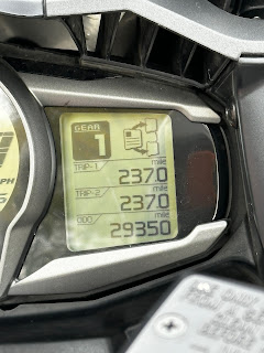
At the end of our tour of Hwy 89 we headed east on Hwy 12 toward Harlowton, a 55 mile stretch though vast ranch lands.  At one point I glanced down at my odometer and saw that I’d hit the 29,000 mark.  There was a pull off just in time to grab a photo.


I bought the bike, new, in April 2021 and figure that with having it stored during our winter-no-riding months (December through March), I get 8 months per year of riding in.  I think that makes about 22 months of riding to cover those 29K miles, or about 1,300 miles per month.  I guess one can say that I like it.

Ah, the open road….


In Harlowton we made a gas and comfort stop/


From the rest stop we could see snow covering the Crazy Mountains.


The ride to Billings was fine, a road I’ve done numerous times, and glad to be getting though it before dusk as it is a known highway of death for the local deer population.  

I pulled into my driveway at 6:22 pm.  It was a 434 mile day with 817 miles for the trip.


While is was a bit late in the year to attempt an overnight ride, it was more than worth it.  We dodged the incoming wet weather, covered lots of miles, and I saw parts of the state I’d never visited before, not to mention the side trip to Canada. That was a lot for just 2 days.

The bike needs a good washing and then it will be ready for a few more rides before it gets put away for the winter.  There are quite a few day rides I’m thinking of before that happens.

One last thought after going through LOTS of small towns.  It’s tough, economically, to make a business survive in these places evidenced by the many abandoned or boarded up buildings.  However, it seems that the last to survive is a bar.

Here’s our trip map:

.


The last ride again

December 28, 2024 Is it really the end of December in Montana?  It sure doesn’t feel like winter but looking ahead on the weather app it app...